Flood Watch - Helene - Thursday, September 26, 2024
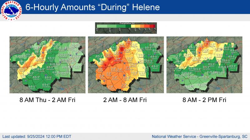
The National Weather Service has issued a Flood Watch for our area. The details are included below. The graphic illustrates the rain that is projected from now until Friday afternoon.
Please use caution around low-lying areas including rivers and streams and any areas subject to flooding. The Town of Lake Lure, NC has been lowering the lake to accommodate incoming rain and water from surrounding tributaries. The lake level is currently at 987.12 Mean Sea Level (MSL).
* Call 911 if you have an emergency.
* For questions, please email Communications@townoflakelure.com
Please use caution around low-lying areas including rivers and streams and any areas subject to flooding.
WHEN: Through Friday afternoon.
IMPACTS: Excessive runoff may result in significant and damaging flooding of rivers, creeks, streams, and other low-lying and flood-prone locations. Areas that are not typically impacted by floodwaters may flood. Numerous landslides are possible in areas of steep terrain. A couple of large, damaging debris flows are possible.
ADDITIONAL DETAILS: Multiple rounds of heavy rainfall are expected due to the interaction of tropical moisture along a stationary front, followed by the passage of Tropical Storm Helene. Storm-total rainfall of 10 to 15 inches with locally higher amounts is expected along the entire length of the Blue Ridge Escarpment with widespread 5 to 9 inches expected across the remainder of the mountains. This has the potential to be an extremely rare event with dangerous catastrophic flash-flooding along numerous streams. - http://www.weather.gov/safety/flood
PRECAUTIONARY/PREPAREDNESS ACTIONS: A Flood Watch for flash flooding means there is a potential for rapid onset flooding based on current forecasts. Flash flooding is a very dangerous situation and may impact areas that do not typically flood. Please monitor the latest forecasts and be prepared to take action quickly should Flash Flood Warnings be issued. Rainfall of more than five inches in similar storms has been associated with an increased risk of landslides and rockslides. If you live on a mountainside or in a cove at the base of a mountain, especially near a stream, be ready to leave in advance of the storm or as quickly as possible should rising water, moving earth, or rocks threaten. Consider postponing travel along mountain roads during periods of heavy rainfall. Low-lying areas adjacent to streams, including campgrounds, are especially vulnerable to flooding. If you live or are vacationing next to a stream, please have a plan in place to seek higher ground once heavy rainfall develops. Flash floods can occur quickly and overwhelm adjacent low-lying areas with little warning. Once the stream starts to rise, you may only have minutes to evacuate. Flash floods can cause catastrophic damage and be powerful enough to sweep away campers, vehicles, and mobile homes. Consider temporarily relocating away from streams until the heavy rainfall threat passes.


