Hurricane Helene Summary Memo
Schnabel Engineering South, P.C. (Schnabel) assisted the Town of Lake Lure (Town) as the Town’s dam safety engineering consultant before, during, and after Hurricane Helene, which resulted in an average of approximately 22.5 inches of total rainfall across the Lake Lure Dam watershed from September 24 through September 28, 2024. Hurricane Helene caused catastrophic damage to the Town and surrounding areas after making landfall in Florida and traveling up the east coast.
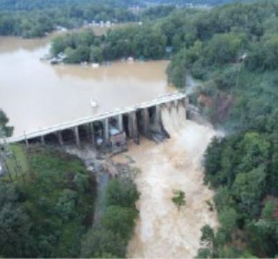
On the morning of Friday, September 27, the dam’s Emergency Action Plan (EAP) was activated and elevated to an “Event Level 1, RED URGENT!! DAM FAILURE IMMINENT OR IS IN PROGRESS” due to water flowing over the low-level arches at Bays 4 and 5 (elevation 992.1) and the mid-level arches (photos 2.1 and 2.2) at Bays 9 through 13 (elevation 994 MSL) and continuing to rise above the bottom chord of the bridge (elevation 998.1 MSL). Notifications were made and emergency responders traveled door to door for downstream evacuations. The peak reservoir level rose to within about 3 to 4 feet below the dam crest at the abutments, flowing over all the arches except the tallest arches in Bays 6 through 8 (where the powerhouse and AC breaker building are located).
In general, the concrete portions of the dam performed as intended; however, internal erosion occurred within the earthen embankment portion of the dam at the left abutment, creating three depressions across the crest and a slide on the downstream slope. Schnabel personnel arrived onsite around 6:00 PM on September 27 and performed an inspection, which continued on Saturday, September 28. At the time of our site visit, it was our understanding from discussions with local emergency responders that there were no reported casualties in the downstream inundation zone of Lake Lure Dam.
The purpose of this memorandum is to summarize the dam operations during the hurricane, project communications and meetings, observations, recommendations for emergency repairs, and additional preliminary discussions. We have included meeting minutes from an onsite meeting held on the afternoon of Saturday, September 28, between the Town, Schnabel, and Morgan Corp. (contractor for the Reservoir Drain Project) as Attachment 1. A photo log of select site photos is included as Attachment 2. A photo markup of recommended emergency repairs, which were based on discussions in the meeting referenced in Attachment 1 and updated based on follow-up discussions, is included as Attachment 3. A photo log of select site photos for the emergency repair construction is included as Attachment 4.
Elevations reported in this document reference the National Geodetic Vertical Datum of 1929 (or Mean Sea Level, MSL) unless noted otherwise. According to the National Oceanic and Atmospheric Administration (NOAA) NGS Coordinate Conversion and Transformation Tool (NCAT), the height conversion from the National Geodetic Vertical Datum of 1929 (or Mean Sea Level, MSL) to NAVD88 is to add 0.56 feet.
DAM OPERATIONS DURING HURRICANE HELENE
The Town reported the lake level was lowered in advance of the peak storm inflows to approximately 4 fee below the normal maximum operating level (elevation 990 MSL) to create additional reservoir storage. The lake level continued to rise due to increased inflow and peaked around 11:00 AM on Friday, September 27, 2024. The maximum spillway gate opening was 12 feet at each of the three spillway Tainter gates, which occurred during the period of peak inflow on September 27. The trash gate operation is unknown; however, the trash gate has a small effect on outflow during the flood.
The gates were lowered to 9 feet open, then 8 feet open by the night of September 27. The peak reservoir level, based on observations by Town operations personnel, was estimated to be 3 to 4 feet below the dam crest, which is 1 to 2 feet below the tallest arches in Bays 6 to 8, and corresponds to approximate elevations of 999.1 to 1000.1 MSL. The peak tailwater elevation was estimated to be at approximate elevation 915 MSL, based on visual observations by Town personnel seeing the tailwater at a PVC pipe joint on the downstream side of the powerhouse, approximately 3 to 4 feet above the powerhouse upper level finished floor. We estimate the maximum outflow to be approximately 30,000 cfs, which is somewhere between 50% to 60% of the NCDEQ Dam Safety’s draft 2024 Probable Maximum Precipitation (PMP) values.
The lake level receded to normal pool (elevation 990 MSL) by Saturday morning, September 28. Wind speeds onsite were not reported; however, conditions at the dam during the hurricane reported by the Town were that wind speeds were relatively low compared to previous hurricane events, despite the large amount of rain. One resident we encountered at the Sunny View Fire and Rescue approximately 7 miles south of the dam observed rainfall totals in excess of 20 inches during the
hurricane from the rain gauge installed at his house. This is similar to the National Oceanic and Atmospheric Administration (NOAA) reported rainfall totals, which showed approximately 22.5 inches in the Lake Lure watershed from September 24-28, 2024. The preliminary rainfall estimates averaged over the watershed, according to NOAA (https://water.noaa.gov/) are shown in Table 1.
Table 1. Lake Lure Watershed Preliminary Rainfall Estimates, Averaged Over the Watershed (NOAA)
Date Rainfall (inches)
September 24, 2024 0.5
September 25, 2024 1.5
September 26, 2024 5.5
September 27, 2024 10
September 28, 2024 5
Total for September 24-28, 2024: 22.5


